Hey folks, Robert Atkinson here—Conyers local, FAA Part 107 certified drone pilot, and the guy behind Prop-er Perspective. If you’re in construction around Rockdale County or metro Atlanta, you know how fast things move… and how quickly delays can pile up from manual inspections, weather hold-ups, or just trying to get eyes on hard-to-reach spots.
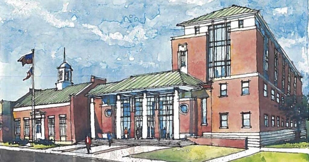
Right now, one of the biggest projects in our backyard is the new Rockdale County Judicial and Administrative Complex in downtown Conyers. This $140 million beast broke ground in late 2024, topped out structural steel in January 2026, and is on track for the Admin Building to wrap in Q3 2026, Courthouse in Q4 2026, with full site work and parking finishing by mid-2027. It’s a game-changer for our county—modern courthouse, admin offices, green space, better security, and expanded parking to serve us for decades.
But big builds like this come with big challenges: constant progress tracking, stockpile measurements, safety checks on elevated work, and documenting everything without shutting down crews or risking falls. That’s where professional drone services shine—and why teams using them are cutting inspection time by up to 60% (based on industry reports from DroneDeploy and similar platforms in 2025–2026 data).
Why Traditional Inspections Slow Down Projects Like the Judicial Complex
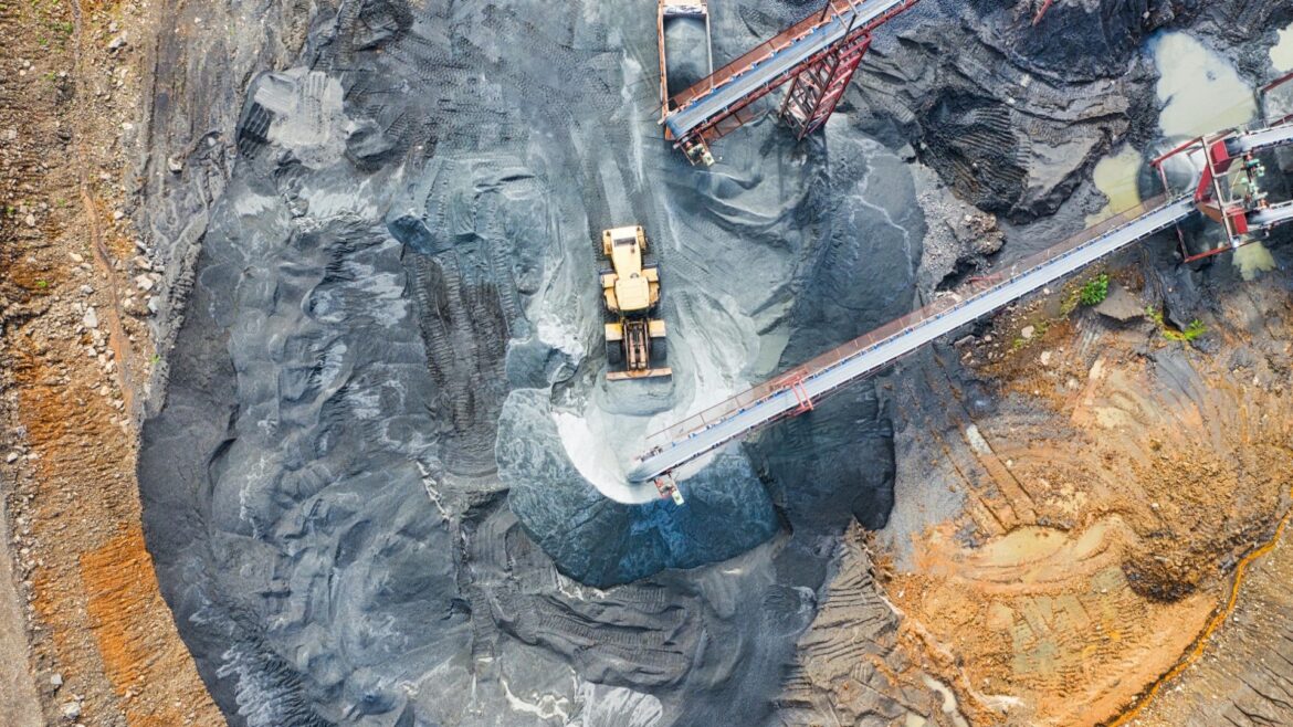
On a site this size (new 115,593 sq ft courthouse + 74,117 sq ft admin building + annex reno + 240-space parking deck), crews rely on ground surveys, scaffolding, boom lifts, or walking the site daily. It takes hours (or days) to cover everything, especially with road closures around downtown Conyers affecting access.
Issues pop up: inaccurate stockpile volumes lead to material over/under orders, missed early cracks or erosion cause rework, and sending people up high increases injury risk. In a growing area like Rockdale, with projects stacking up (like the I-20/SR 138 interchange widening and Courtesy Parkway extension), these delays add real dollars—labor, equipment rental, penalties.
How Drones Deliver a Prop-er Perspective—and Slash Time by 60%
Drones flip the script. A quick 15–30 minute flight captures high-res photos, video, orthomosaics (stitched aerial maps), 3D models, and precise measurements. No scaffolding, no shutdowns, no putting workers at risk.
Real-world numbers from 2025–2026 construction drone reports:
- Drones survey up to 100–120 acres per hour vs. 5 acres manually—60x faster data collection.
- Progress monitoring reduces overall project time by up to 20% in some cases.
- Surveying costs drop 40–60% (e.g., one contractor replaced full-day manual inspections with 15-minute flights, saving 5 man-hours per visit).
- Stockpile volume accuracy hits within 1–2% error, avoiding costly misorders.
For the Judicial Complex specifically: Weekly or bi-weekly drone flights could map the entire site footprint, track rebar placement (like from local partner Anasteel), monitor earthwork around the parking deck, and spot any settling or drainage issues early—especially with the phased timeline and downtown constraints.
Local Rockdale Projects That Would Benefit Right Now
Beyond the Judicial Complex, Rockdale has several active builds where drones save the day:
- I-20 @ SR 138/SR 20 Interchange Reconstruction — Under construction since 2024; drone flights track bridge widening, lane additions, and the new single-point urban interchange without lane closures.
- Courtesy Parkway Extension — 1.5-mile new roadway from Old Covington Hwy to Flat Shoals Rd; aerial mapping ensures grading accuracy and erosion control on this urban connector.
- Sigman Road Widening Phases — Ongoing improvements; drones monitor traffic detours, material placement, and safety zones in real time.
In all these, drones provide timestamped proof for stakeholders, help resolve disputes fast (e.g., “Here’s the exact progress on Feb 20, 2026”), and keep everything FAA-compliant.
What a Typical Drone Progress Package Looks Like for Conyers Contractors
As your local guy, here’s what I deliver:
- Custom flight plan — Tailored to your site (e.g., Judicial Complex focus on structural steel, foundations, or site grading).
- High-res visuals — 4K photos/video, orthomosaics for overlays in your software.
- Data deliverables — Volume calcs, progress comparisons (week-over-week), annotated hazard reports.
- Safety first — I handle all FAA regs, pre-flight checks, and no-fly zone avoidance (like near downtown Conyers restricted areas).
- Fast turnaround — Images and reports in 24–48 hours, often same day.
Cost? Often pays for itself in one avoided rework or delay—many Rockdale teams see ROI in weeks.
If you’re on a Rockdale project—whether the Judicial Complex, a road build, or your own site—let’s get you that clearer, safer view from above.
Ready to see the difference? Book a free 15-minute site demo flight—no strings, no sales pitch. Just useful aerials you can keep and use. Drop a comment below, email me at [your email], or call/text [your phone]. Conyers-based, local, and ready to fly.
What challenges are you facing on your current build? Let’s chat drones.
Thanks for reading—stay tuned for more Georgia-grounded insights on Prop-er Perspective.
Robert Atkinson
Conyers, GA Drone Services Expert
Leave a Reply